Showing posts with label Yukon. Show all posts

Thursday, August 16, 2012

Alaska -- Day 92

Just when we thought we had seen all the beautiful mountain scenery Canada and Alaska had to offer, we drove the Haines Highway from Haines Junction in Yukon Territory to Haines, Alaska, on the Inside Passage. The trip took us from Yukon Territory to a small part of British Columbia into Alaska. The mountains are amazing.


So were the lakes. This is Dezadeash Lake.


We went over Chilkat Pass, elevation 3510 ft. But it reminded us a lot of driving over 12,183 ft. Trail Ridge Road in Colorado's Rocky Mountain National Park. The alpine environment here is just at a much lower altitude.


Very soon, however, we were back down in the forest.


And, of course, Colorado doesn't have glaciers.


When we came to the Chilkat River, we saw fish wheels.


This picture of tundra swan on a small lake has to be the prize of the day. I was looking through the side window, back over my shoulder.


Back on July 20, we visited Anchor Point, North America's most westerly highway point (see Day 65). Two days ago, we stayed in Beaver Creek, Yukon, Canada's most westerly community.


Today, as we pulled into our RV spot in Haines, the neighbors were showing off the salmon they caught here in Haines.

Wednesday, August 15, 2012

Alaska–Day 91

Yukon Territory is huge. On a provincial park sign we saw the slogan, “Yukon, Larger than Life.”  We spent seven days in Yukon on our way to Alaska and we will drive through the province for three days on our way to Haines.  There is a vast expanse of wilderness, covered with forest and lakes.  We tried very hard to take it all in today.  After our drive tomorrow, we may never come through here again. 

This is a long and daunting journey with a 36-foot 5th wheel trailer, especially at our age.  I don’t know that I would want to go through it again.  In addition, we both feel we have seen and experienced everything we ever wanted to see here.  It has been wonderful.  But we are full, and tired, and ready for the familiar and for staying in one place for weeks at a time.

What did we relish during our trip today?  There were numerous ponds and small lakes.  This country, which often sits on permafrost, has innumerable such ponds.  Often they are smooth and reflect the surroundings. This first picture shows a trumpeter swan floating on the lake, though I don’t know if you can make it out.  A little later, we saw two of these swans flying overhead.  How cool is that?  Where else could we see that?

IMG_6810

IMG_6825

The road today was rugged most of the way, with frost heave and pot holes.  But the ride was worth it.  We saw the beautiful St. Elias Mountains.  We had seen the other side of this range three days ago, driving north from Glennallen to Tok.  These mountains are part of the Wrangell and St. Elias National Park in Alaska and Kluane National Park in Canada.

IMG_6815

We saw colorful mountains that make us wonder what the early settlers could mine there.

IMG_6841

And our eyes feasted on Kluane Lake with its miles of shoreline and many acres of deep blue water.

IMG_6843

We have seen 30 bear during this trip, 14 in Canada on our way to Alaska, 16 in Alaska.  We hoped to see more today.  We did.  Number 31.  As we drove along Kluane Lake, we saw this fat grizzly bear crossing the road.  I took several pictures, including this one as he walked down to the lake’s shore.  It was icing on the cake as we savored our last days in Canada.

IMG_6847

This photograph shows you what I mean when I talk about a vast wilderness.  It seems to go on and on, almost forever.

IMG_6862

Finally, the valley spread out to include these open fields with pretty yellow flowers and rail fences.  We wondered where the cattle or wheat fields were.  Do they have them here?

IMG_6869

We have been so blessed to have the time, the finances, the proper transportation and the good health to make this trip.  We have seen such beauty.  And I have over 5,000 pictures on my computer to help us remember it in the years to come.

Tuesday, August 14, 2012

Alaska–Day 90

Today we left Alaska, at least mainland Alaska, and drove into Yukon Territory.  The border crossing was completely uneventful. “Let me see your passports, Where do you live?, How long will you be in Canada?, Will you be dropping anything off in Canada?  Have a good day.”   I’m glad I didn’t get rid of any fresh vegetables.  When we entered Alaska, I had to give them my tomatoes.  Then I drove to a grocery store and bought some more tomatoes from Mexico.  What is the issue?  Anyway, today it was easy and quick.

We spent 46 days in Alaska, after 32 days moving through Canada.  Since leaving Colorado May 17, we have driven 7,127 miles.  Most of that was towing the trailer, although we have probably driven 500 to 700 miles sightseeing without it.  We drove 2,748 miles in Alaska. Plus, we drove 1,838 miles between leaving Santa Ana NWR and leaving Colorado.

We have approximately 450 miles of driving between Tok and Haines.  Our ferry ride to Bellingham, Washington, will take three and a half days.  Even counting the four days we will spend in Haines, our trip from Tok to Washington will only take 10 days.  It may be expensive, but we are certainly glad we don’t have three weeks of driving to reach the border.

Today the road was very rough most of the way.  We saw frost heave, pavement breaks and gravel patches.  When John opened the refrigerator after we were parked, the orange juice container fell out and came open, spilling juice all over the kitchen.  Thank heaven the floor is vinyl, not carpet.  Two shelves in the door had come loose, as well as two regular shelves sliding out of place.  What a mess!

Thursday, June 28, 2012

Alaska–Day 43

Today we had great scenery as we drove from Whitehorse to Beaver Creek.  But about all I can say about the road condition is, “yikes!”  At first we planned to stop at Congdon Creek Provincial Park along Kluane Lake.  But it was cold and threatening rain, so we decided electrical hookups would be good.  Just look at these mountains.

IMG_1774IMG_4875IMG_4920IMG_4909

Kluane Lake is the largest lake in Yukon.  It covers approximately 154 square miles.  In addition to the hundreds of thousands of acres of timber we have seen in Yukon, the amount of water in lakes and rivers is amazing.  Earlier today we drove near, but couldn’t see, Kusawa Lake, which is 45 miles long and averages 2 miles wide.  Here are a couple of pictures of Kluane Lake.

IMG_1790IMG_4892

The wildlife that we saw today was three horses on the road and two bears on a hillside.  Here is the mama horse and colt. Dad was bringing up the rear, making sure the colt got across the road.

IMG_4901

A little later we came on this black bear, which is brown, and her black cub.

IMG_4919

If you have never driven in the north, you may not know what frost heave is.  Quoting The Milepost, “According to Public Works Yukon, much of the soil along the north Alaska Highway is of glacial origin and unsuitable for road embankments… ‘Anything that causes the permafrost to melt will cause the ice-rich soil to liquefy, and liquid soil has little strength and will settle or subside.  Then if this soil refreezes during lower air temperatures, it will expand or heave.’”

Here is what the highway looks like in patches of frost heave.  Look at the white lines along the sides. It shows where the bumps and dips are.

IMG_4898IMG_4899

So what happens in the RV when we drive on these roads?  Look at this.

IMG_1803IMG_1804

Again from The Milepost, “Vent-like structures alongside the highway here are part of the Alaska Highway Permafrost Research Project, which is testing specialized construction techniques..to minimize melting.”   Drivers in future years will benefit if they get this figured out.

 IMG_4923IMG_4924

The condition of some sections of the road is awful.  But there is almost no traffic, which allows us to go as slow as we want.  Along some stretches of the road today we went between 30 and 40 mph.  Most days John has been staying between 50 and 55.  We have more time to take in the scenery.  Plus, we are getting 13+ miles per gallon at these speeds.

Wednesday, June 27, 2012

Yukon River Quest

This is the longest canoe and kayak race in the world, 444 miles down the Yukon River from Whitehorse to Dawson City.  It began at noon today.  There are 68 teams, 187 paddlers from 13 countries, including Israel and Latvia.  Paddlers range in age from 18 to 80 and go solo and in teams of up to 8 people. 

Just after 9 this morning, paddlers were getting reading for the race.  Boats were on the river edge and gear was being stowed.  The race course crosses Lake Laberge, a 31-mile long widening of the Yukon, the first big hurdle.  The water is very cold and paddlers may encounter waves up to 5 feet high.  It was only 51 degrees when the race began.  They will hit the lake later this evening.

IMG_1651IMG_1652

IMG_1653

The paddlers mass on the lawn next to the lake and then, at the start signal, they race to their canoes and kayaks.  Within less than 2 minutes the first boats were on their way.  In 7 minutes the last canoe was underway.

IMG_1738IMG_1741

IMG_1749IMG_1743

IMG_1771

There was quite a crowd watching the start, wearing a great variety of clothing.

IMG_1720IMG_1725

IMG_1726IMG_1730

Some people had signs, supporting their favorite team.

IMG_1735

One photographer went all out (into the water) to get his pictures.

IMG_1717IMG_1769

Racers go to Carmacks, 112 miles by car, 2 hours 18 minutes, where they have a mandatory 7-hour rest break.  I don’t know how fast the best racers make this part of the trip, but anyone not getting there in 32 hours is disqualified.  The second leg is Carmacks to Dawson City, 219 miles, 5 hours 15 minutes by car.  The record winning time on the water is 42 hours.  I can’t imagine!

If you want to follow the race and see the results, go to: Race to the Midnight Sun

Alaska–Day 42

Yukon government, Yukon River Quest and Yukon history highlighted our day here in Whitehorse.  There was so much, I will split it into two posts.

The Yukon Government building, constructed in 1979, is a very modern looking building.  We visited because The Milepost, the bible for traveling to Alaska, described a mural and tapestry there that we wanted to see.

IMG_1659IMG_1660

The 120-foot acrylic resin mural traces the history of the development of Yukon. These pictures in the collage don’t quite fit together, but they are in order, left to right.

2012 June2

We asked at the information desk about the tapestry in the Legislative Chamber, measuring 18 by 12 feet, that is an abstraction of the fireweed plant, Yukon’s floral emblem.  We were given a short tour by Fay, who showed us the chambers and told us something about the legislature.

John and Fay

IMG_1677

The assembly has 19 members that are in office for a 5-year term.  There are three political parties, the Yukon Party, which is a ruling (majority) party; the New Democratic Party, the opposition; and the Liberals, who are the third party.  Apparently, the debates in the legislature can be as vigorous as you see on TV in the British parliament.  But, outside of the chamber, Fay says they are friendly to one another.

The banners on the walls show the symbols from the Yukon flag—mountains, streams, mineral resources, and the Cross of St. George representing the British Commonwealth.

We also visited the McBride Museum of Yukon History.  There we saw many of the animals of Yukon, such as the beaver and musk ox.

IMG_1682IMG_1686

They have the cabin home of the real Sam McGee.  Robert Service and McGee both worked for the same bank and Service liked McGee’s name.  He asked permission to use it in a poem he was writing, “The Cremation of Sam McGee.”  You can learn more about the poem and Service on the web.

IMG_1692IMG_1693

Whitehorse got its name from the rapids on the Yukon River that reminded First Nation people of the manes on white horses.  This hotel sign at the museum shows the white horse symbol of the town.

IMG_1698

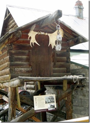
People living in the wilds of Yukon needed a place to keep their food safe from bears and other wildlife and away from where they were sleeping and eating.  They would build a cache like this for storage.
IMG_1704

Today most goods shipped across the oceans and the country by ship, train or truck are placed in containers.  The White Pass and Yukon Railroad developed the first containers to speed and simplify shipment of goods from Yukon to the outside world.

IMG_1710

We even saw a sewing machine that was used to make sails for the Klondike stampeders sailing the Yukon River to the gold fields.  I am really partial to Singer sewing machines.  My mother worked for the company, they paid a scholarship that helped with my college expenses, and I own a Singer.

IMG_1713