

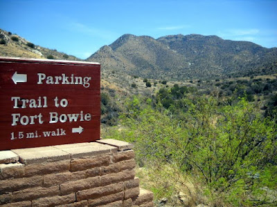
Then hiking a mile and a half from the parking lot to the Fort ruins and Visitor Center.
From looking at the markers along that trail, we imagine that walking 1 1/2 miles is unusual for many visitors. They need to know how far they have gone (and how far they have to go yet).

Fort Bowie was built by soldiers from the 5th California Volunteer Infantry in 1862 and helped guard Apache Pass and the Apache Spring until it was closed in 1894. Troops there guarded the spring, which provided water for the Fort, passing travelers, and the Butterfield Stage. They also helped control the Chiricahua Apaches, led first by Cochise and then by Geronimo. To learn more about Fort Bowie, you can check out the NPS home page or Wikipedia's information.
This is the spring today. It isn't very big, but a well draws water just upstream from here.

In several places, the stage route is still visible. Pretty impressive when you realize it only operated from 1858 to 1861.

This shows the foundations of the nearby stage station.

A graveyard along the trail once contained the bodies of numerous soldiers as well as stage passengers and others killed during the years of fighting with the Apaches. Most soldiers were moved to a government cemetery when the Fort closed, but this one soldier's grave remains. Geronimo's young son is also buried here.

Only a few low adobe walls remain of Fort Bowie.

The Apaches migrated to the southern plains of North America by 1300 and into areas of the present-day American southwest and northwestern Mexico about 1500. The park service has built a wikiup, similar to what the Apaches would have lived in during the years Fort Bowie was open.

No comments:
Post a Comment