Thursday, July 05, 2018

Capitol Reef

The geology in Utah creates many beautiful and unusual rock formations. After leaving Bryce Canyon, we came to Torrey where we have driven the scenic road and hiked during the past week. We have been here before, but it was still worth it to spend time this year. The formations are different than we saw in Bryce. Not as many hoodoos.


We were interested in the steaks of color running down the cliff faces. I think the dark color is called varnish.  I wonder if the light streaks are dissolved light-colored rock.


Here you can see the many different layers of rock running across the landscape.


On Tuesday we hiked the 2.2 mile Grand Wash.  That make a 4.5 or so mile round trip.  We were dwarfed by the high rock walls in the wash.


We found this free-standing rock in the wash.  Thought it looked like a space ship.  Are we sure we are in Utah and not the weird part of New Mexico?


John climbed up into this small cave for a rest.


The national park includes the early settlement of Fruita where Mormon pioneers planted several orchards.  Visitors were able to pick the ripe apricots while we were there.  They are charged only a small amount for every pound of fruit.  The apricots were so small, we passed on picking any.


It isn't often you see a marmot crossing.


Capitol Reef is named for a large white stone formation early explorers thought looked like the dome of the U.S. Capitol.  The white formation on the left here may be that dome.


On the 4th of July we hiked the 1 mile trail to Hickman Bridge.  Not far from here at Arches National Park there are lots of bridges.  There aren't so many here but we found here.


Nearby, John noticed another small arch or bridge.


As we headed back to our truck we walked up this staircase.  It looks a lot more like stairs then the Grand Staircase we drove down last week.

Wednesday, July 04, 2018

Going Down the Stairs

Geologists describe the many rock layers visible in Utah as the Grand Staircase--a place where layers of rock are like the chapters in a huge history book that describe how Earth developed.  It is the world's most complete sequence of sedimentary timespans from sediments built up in lakes, inlands seas, swamps, deserts and forests.  (Thanks to the National Park Service Bryce Canyon brochure.)

When we left Panguitch near Bryce, we were near the top of the staircase.  We drove downhill through the pink, gray, white, chocolate and vermillion cliffs to get to Torrey and Capitol Reef National Park.  From here we will go further down and south to Blanding, Utah, then around the Grand Canyon, to Flagstaff and Gold Canyon.  The multi-layers of rock on the staircase reach the bottom of what is visible at the base of the Grand Canyon.

I could title this blog "Beautiful, Incredible Utah--Part 2."    Below are photos of the many layers from outside Panguitch and heading south.


In places the roadway was very narrow with no shoulder.  Nowhere for the timid flat-lander to drive.  Our lifetime in Colorado made it a fairly easy trip for John.


Sometimes it looked like we were really in a desert.  Other times we were in a pinon-juniper forest.


We may have been going down the staircase but in places we had to go up to get over or around the rocky hills.  The view could be expansive.  We went up to 9600 feet above sea level before heading down to Torrey and Capitol Reef where we are at 6800 feet.  We saw lots of 8% and 10% grades.  No place for RVers who are overloaded.


A blog on the beauty of Capitol Reef is coming by tomorrow.

Sunday, July 01, 2018

Panguitch


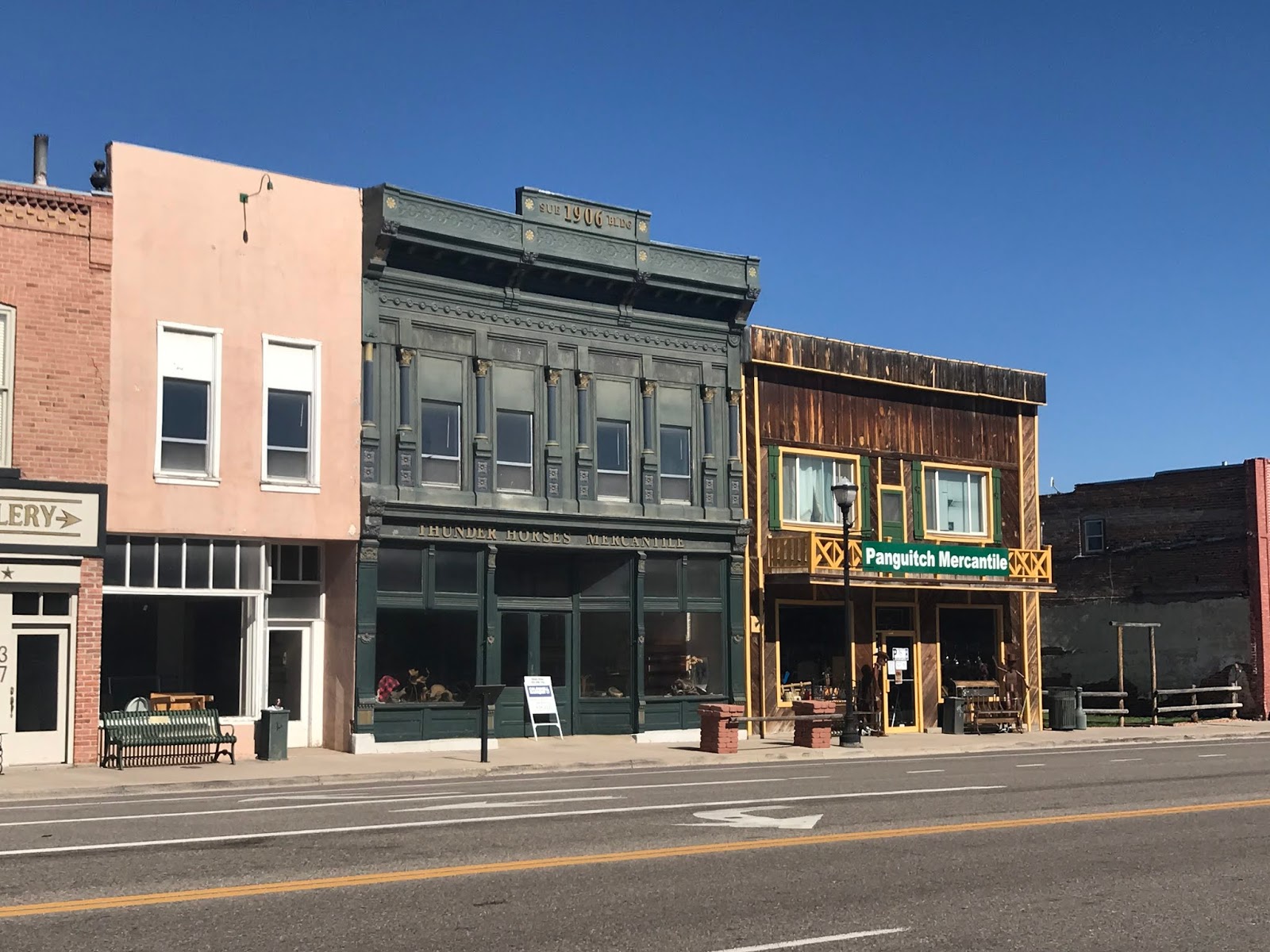
We stayed in Panguitch while visiting Bryce Canyon.  That is the town where we did our grocery shopping when we volunteered at Bryce and it was the closest we could find a campground spot.  I enjoyed walking on historic main street in the town, looking at all the neat brick houses.  We learned that early residents started making bricks for settlers to build their homes.  It makes for an attractive central town area. 


This one has a much better yard.


The homes are built in numerous different styles.


We also saw some neat old commercial buildings.


It was a fun town to tour.

A Hell of a Place to Lose a Cow

That is what the rancher Mr. Bryce said in describing what is now known as Bryce Canyon National Park in Utah.  You can see why.


We spent 3 months volunteering at Bryce in 2005, the first year we spent being work campers.  We fell in love with the place.  It was fun to hike there twice last week. 
Every bend in the trail offers new and beautiful views.   The first time we visited the park—I think in 2003 right after we both retired- we didn't know any better so we drove along the rim and looked at each of the viewpoints.   When we came to work we started hiking down the trails.  Our assignment required us to spend one half of each day helping on the visitor's desk and the other half hiking the trails if we wanted to.  If we wanted to!  We loved it.  Even though we had to hike separately a lot of the time, we each hiked all of the trails in the park, more than once.  We were very comfortable on the visitor desk helping people figure out what they could see in the amount of time they were there visiting.
This visit we took 2 good hikes.  One day we hiked on the most popular trail close to the visitor center.  The second day we drove to the highest point in the park, Bryce Point, and hiked down and back to the center and up through Navajo Loop. 
It seems Bryce Canyon is a hell of a place to lose a new employee, too.  As we came down from Bryce Point, a young man who was clearly on the maintenance staff at the park came toward us and asked if we had seen a yellow machine being used on the trail we had come down.  We said no, we had seen nothing like that.  "Oh no," he said. "I took the wrong trail."  He hurried forward and up toward the rim.  About ¾ of a mile further we encountered a middle aged maintenance worker and asked  him if he was looking for a yellow machine.  "No,  I'm looking for a lost employee."  We explained we had passed him back a ways.  He hurried off in the same direction the young man had gone.  And we walked on, laughing.  There are lots of trails to search on foot for a missing person in Bryce.
Here are some of the views we saw along our hike.


Guided horse and mule rides go through the canyon each day.  This is one of three groups we passed on our hike.  Hikers stand aside on the uphill side of the trail to let the animals and their riders go past.  We were family with the routine but I am still nervous when the big animal with a very inexperienced rider passes me.


 We hadn't encountered many hikers until we began our ascent on the Navajo Loop.  Look at how many people headed for the narrow canyon ahead.


Walking up this busy trail, we stepped aside to let a younger couple pass us.  Instead of going on, we started talking and were in conversation until we reached the rim.  I asked them where they were from and they said, "Sweden."  John said, "Sweden, I'm half Swedish."  We talked for a while more.  They lived near the area Joh's cousin Birgitta lives.  They are visiting America on their honeymoon.  We had a delightful time with Jacob (not sure I am spelling is correctly) and Anna.


Tuesday, June 26, 2018

Beautiful, Incredible Utah

Way back in 2003 we made our first trip into Utah--frankly not expecting much.  We soon found out there is so much variety and beauty in this state as you go from one area to another that we have been work camping volunteers in two different location--spending 5 months or more here--and visited again 2 or 3 times.

This year we came in on I-70 from Colorado.  The eastern edge of Utah isn't impressive there, but we have come from Green River on to Panguitch--near Bryce Canyon--and we have enjoyed nearly every turn in the road.  Just look at what we have seen.

As we left Green River this neat old dead tree stands in front of the landscape.


In the distance we could see the beginning of interesting rock formations and colors.


Sometimes the colors are muted beige and gray.


Then we saw green--ponderosa, pinyon and juniper.


This is called Ghost Rock.


A mixture of white and green.


And then, stunning Bryce Canyon.  We spent 3 months living in Bryce the first summer we did work-camping.  We love it and have returned several times since.  I will do a whole blog on this place.


Sunday, June 24, 2018

Hanging Out in Green River

We are slowly making our way west and south, headed for our Gold Canyon house. It is hot there and so we taking a lot of time to make this trip. Once at the house, we will pack and prepare to fly out of Sky Harbor Airport to London. But that is almost a month away.

Monday, June 18, 2018

No internet!

How life had changed! We have been RVing for30 years and until recently, we rarely had internet access. We most often stayed in state parks and forest service campgrounds. When we stayed in commercial campgrounds, to get our email we had to go to the office or the office porch to plug into an outlet on the pay phone or be close enough to use their WiFi. Once in Alaska we even used the fax line in the harbor master's office. In Prince George, British Columbia, they gave us a suitcase which supposedly gave us internet access. We never got it to work.

We could get our email in these situations. How many of you remember email you could download, then read after you disconnected to the internet? We would compose responses then go online in the park office to send them. Today, we have to be online to read the email and to compose and send the response.

We used a pay phone to call for reservations. Who heard of researching local attractions or hiking trails on line. We called home once a week to find out if everyone was OK.

Today, we are used to internet access almost everywhere we go. We can talk to family and friends day or night and are online in our RV, as we drive down the road—everywhere.

That is, most of the time. For 5 days we are at Rifle Gap State Park. We have not been here before but it is great—huge sites, good views, full hookups. But we don't have internet or cell phone access. It is Father's Day and we expected a call from our sons to John. Good luck. We can't call each other here in the park. So no one else can reach us, that is for sure.

As we did in years gone by, we will go somewhere each day to check our email and make any phone calls we need to make. How often in the past did I go to the park office where we were volunteering to check our email. One park where we volunteered, the only cell phone access was down by the lake. Another time, it was crossing a bridge over a river as we entered the park. We would stop there and I would call the bank's automated system to check all the checks that had cleared the account. In Montana, we drove into The Dallas several times a week to check the internet and make phone calls.

Ask me if I am nostalgic for days gone by and happy to be repeating the situation. Not on your life! However, we are going to England for 2 months this summer and know that at times we will be in this same situation. At least it is good practice.

We do have TV reception here, but without the internet, would you believe we actually played Gin Rummy this afternoon. And it was fun! I don't think we have done that for 6 years.


Sent from my iPad

Saturday, June 16, 2018

Beauty Going West on I-70

Yesterday we left Grand Lake and drove west on I-70 over Vail Pass and through the Glenwood Canyon. The scenery is wonderful.

A view of Shadow Mountain Reservoir.


Ride the Rockies, a bicycle race held each year over several high mountain passes in Colorado, was in it's last leg.  The riders had spent the night in Grand Lake and were heading down to Granby the Weston US 40 to Kremmling, Highway 9, headed for Silverthorne at I-70.  Unfortunately, that was our route to I-70 so we had to carefully pass at least a couple dozen riders.


A view of what I think is the Gore Range from outside Kremmling.


Islands in Lake Dillon from the interstate.


The green ski trails at Vail Ski Resort.


Then the spectacular Glenwood Canyon along the Colorado River.


One of the tunnels on the canyon route.


Note the 2-level highway here.  Building the 4-lane highway through the canyon took so long, some highway engineers worked their entire career on the road.  They made every effort to preserve the beauty of the canyon as they widened the old 2-lane road to 4 lanes, divided.


And we are seeing the unmistakable sign of the summer travel season--a Cruise America RV.