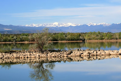
I just love taking pictures of reflections in water. Earlier this week I walked across the Horseshoe Lake Dam here at Lathrop State Park on an unusually quite, wind-free morning. This tree is mirrored perfectly on the lake.
When I walked further and turned around, I saw the same tree with the Sangre de Cristo Mountains in the background.
Deer often feed near our trailer. These two young bucks seem to live on this ridge.
This Bullock's Oriole has been feeding behind our trailer this week.
We have had a busy week in our work camping position. I operate the camp store, or Snack Shack as we are calling it this year. The store had to be cleaned and we went to Pueblo (40 some miles north) to buy inventory. Karen, office manager at the park took us with here to select the merchandise.
Yesterday John cleaned fire pits in the campground, preparing for the Memorial Day weekend. The campground will be full all weekend. I opened the Snack Shack for a few hours.
Sunday afternoon we will drive to Denver to spend the night with our son Eric, and his family.. Then Monday morning (4AM) we drive to the airport for our flight to New Hampshire. We will be there for two weeks. Our older son, Doug, is having colon cancer surgery Wednesday. We will be there to support him and his wife, Sherry, and we will help care for our two granddaughters, Rachal and Samantha.
Saturday, May 28, 2011
Tuesday, May 24, 2011
Finally
Last Wednesday we arrived at Lathrop State Park and quickly got settled in the same site we were in the past two summers. This is a photo from last summer.
Like normal, we leveled the trailer, hooked up the utilities, put out the slides, then started to do things inside the RV. Because the site only had 30-amp electric, we used a adapter that combines the 30-amp with a 20-amp connection to provide something like a 50-amp connection. Because we know that doesn't provide a true 50-amp connection, I plugged in the volt meter so we could monitor the electricity. Unfortunately, every time I turned anything on, the volt meter dived to about 110 volts--not enough to safely operate any of our appliances.
We quickly found Dave, the head of Maintenance here, to help us find out what was wrong. He tested all sorts of things and couldn't locate the problem. He promised to return the next morning and install a 50-amp power pole. We agreed to used our generators for power over night.
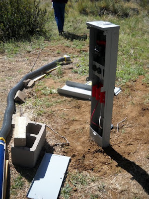
Thursday Dave and Byran and Justin put in this new power pedestal.
When the installation was complete, we again turned on an appliance. Same thing happened--not enough volts. So Dave and Byran checked out the power at the pole.
They still couldn't find what the problem was. Byran, who lives in the house next door, did tell Dave things weren't right in the house, either.
We were told to move to a site in the campground that has full hook-ups while Dave tired to fix the problem. So, we put everything away, moved the trailer less than a mile and set up again. Darn.
Thankfully, the local power company was called out and when the problem was explained to them, they said "That is something wrong on our side." They rewired something simple in the electrical feed and everything is OK. Yea.
Yesterday, we moved back into the site we love and all is well. Thanks, Dave. So we are back to the work of cleaning fire pits, as well as setting up the camp store to open over Memorial Day weekend.
This year we have a small dump truck to clean fire pits. This is how much we picked up this week--it accumulated since last fall.
And there it all goes, into the pit for later burial.
It looks like everything will be fine for the summer. We're glad. And it sure is fun to empty that dump truck!
Labels:
Colorado,
electricity,
state parks,
volunteer
Saturday, May 21, 2011
Back to Colorado
Wednesday we left Santa Fe early--7 am. We almost never get on the road that early, but high winds were predicted for the day and we wanted to get to Lathrop State Park in Walsenburg, Colorado, before the wind kicked up. We have liked New Mexico for years and just spent three and a half weeks there. We saw many wonderful places and enjoyed ourselves immensely. And we still have a lot to see and do there. But it is time to head north to Lathrop, where we are volunteering for the summer.
On Raton Pass we saw this sign.
And then this one.
Colorado is where we were both born and raised, so it is always good to return home. Whenever we are out of the state for a long time, we yearn to see the mountains. This is the sight that greeted us Wednesday.
Thursday morning, while we were doing the dishes, this is what we saw our the window. It is the reason we really enjoy our RV site here.
And this is the view where we go for our runs.
Those are the Spanish Peaks. Here is some information about them.
The Spanish Peaks of south central Colorado have been among the most important landmarks of the southwestern United States, guiding Native American tribes, Spanish and French trappers, gold seekers, hunters, and American settlers. The Ute, Comanche, Apache, and other, earlier Indian tribes held the Peaks in religious awe and named the mountains Wahatoya, meaning "Breasts of the Earth." Even the ancient Aztecs believed the Peaks were a source of hidden treasure. Later travellers named them the Twin Peaks, Dos Hermanos (Two Brothers) and Mexican Mountains.
To learn more, go to www.sangres.com/mountains/spanpks/
Thursday, May 19, 2011
Santa Fe
Santa Fe is another New Mexico town we have visited a number of times. It is fun and interesting. This is a market that has probably existed here for centuries--after all, this city was established in 1610.
And here is the other end of the spectrum, a shopping area that is new and modern and shiny--but many of the shops inside were empty.
I know the altitude in Santa Fe is pretty high for a lot of visitors, but is this really necessary?
We almost never go out to eat, but we did that four times during out stay in New Mexico. In Santa Fe we went to the La Fonda Hotel.
John enjoyed a chicken burrito and my chile rellenos were excellent.
Several of the major hotels had these neat shuttles for their customers.
Several statues surround the Cathedral of St. Francis. This one depicts Don Diego de Vargas Zapata, who reestablished the town of Santa Fe after the 1680 Pueblo revolt.
This one shows the various groups of people and the livestock that are important to New Mexico.
And this is St. Francis Dancing on Water.
We explored a delightful courtyard that contained a restaurant and a wonderful garden.
The courtyard was inside this very old building.
We had heard on the evening TV news that Santa Fe has a real problem with street people and panhandlers. Here are a few hanging out on the plaza.
Look at the top of this building!
Even the manhole covers in Santa Fe are interesting.
We passed a store that sells old doors. I really wonder where they found all of them. They aren't your typical household doors.
For a different perspective, look at this motorcycle.
Tuesday, May 17, 2011
Bandelier
Speaking of Frijoles Canyon and the Ancestral Puebloan homes he found there, archaeologist Adolph F. A. Bandelier called it "The Grandest thing I Ever Saw." In 1916 the area was established as Bandelier National Monument in 1916. The natural environment of the area is beautiful and the pueblo structures are fascinating. The visitor center and other buildings were constructed by the Civilian Conservation Corps during the 1930s.
The Visitor Center is newly remodeled and updated inside and a brand new introductory video, five years in the making, is outstanding. If you visit, don't miss it.
The canyon and mesa country is part of the Pajarito Plateau, formed by violent eruptions of the Jemez Volcano more than one million years ago. The eruptions covered the 400-square-mile area with a layer of volcanic ash up to 1,000 thousand feet thick. The pink rock of the canyon is volcanic ash that compacted over time into a soft, crumbly rock called tuff. This is easily eroded by wind and rain, taking on a "Swiss Cheese" appearance. (This paragraph was written especially for you, Eric.)[Our son Eric teaches earth science to middle school students.]
The Ancestral Pueblo people built structures against the canyon walls, where they could enlarge the small holes, carving out "cavates" to use as additional rooms and storage areas for their buildings.
This reconstruction shows the rock and masonry walls of the buildings and the ceiling beams.
They built fires in the cavates to harden the ceiling surface.
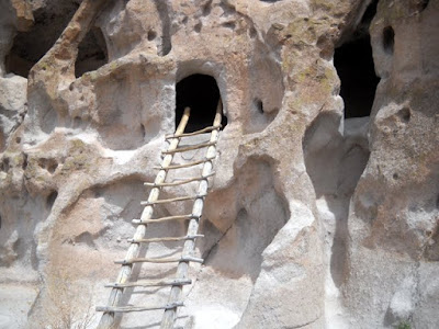
Today some of the cavates are open to the public via these ladders.
There was a surprisingly large number of visitors at Bandelier this week.
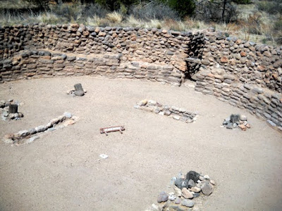
In addition to the buildings against the canyon walls, the ancient people built a large circular pueblo on the canyon floor. Here you can see remaining first-floor walls of the pueblo.
This Kiva is located outside the confines of the pueblo.
Farther up the canyon they built an 800-foot-long stretch of canyon wall structures called Long House. Here you can see some of the cavates (rooms), as well as the rows of holes in the canyon wall that show where beams for ceilings were placed. You can see two rows of holes for two stories here.
This shows both the lower walls of the buildings and the canyon wall rooms.
In this area, we could see some faint petroglyphs.
Archaeologists also discovered this picture, which had been painted on the canyon wall then covered over by plaster.
Frijoles Creek is the year-round source of water that probably attracted the ancestral Puebloans to this canyon.
We walked another half mile up the canyon to see Alcove House. To reach it, we had to climb stairs and ladders 140 feet up the canyon wall. I wondered if we had wandered back to Picacho Peak in Arizona.
It really wasn't as bad as it looks here.
Subscribe to:
Posts (Atom)