Showing posts with label ferry. Show all posts

Friday, August 08, 2014

Island and Caves

Bayfield, WI, on Lake Superior is the home of the Apostle Islands National Lakeshore, part of the National Park Service. We had to check out the islands by taking a cruise. We bought our tickets the day before. At a little after 9 am, we were among many waiting to board the Superior Princess.


We had hoped to get in line early enough to get seats on the top deck, but we were too late. It was nice and sunny up there, but really windy and cold after we got out onto the lake. We were just as glad to have inside seats.


The boat moved pretty fast, up to 25 mph we were told. Look at the wake it leaves.


I'm not sure if this is a sea stack or just a piece of an island that broke off. Or are they the same thing?


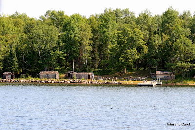
We passed a fish camp on one island. The boat's sound system left a lot to be desired, so I'm not sure if it is used any more or not.


This marker buoy indicates the presence of a fishing net.


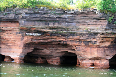
The highlight of the trip and the reason for going was to see the Devil's Island sea caves. The other day, when we saw some caves from the mainland Lakeshore Trail, I thought we were going to see the same caves from the boat. Instead, we traveled to the small Devil's Island on the outside edge of the archipelago.



Devil's Island also has a lighthouse.


Another island with a lighthouse is Raspberry Island. The park service is improving the dock area of the island, so there is construction going on. There is a boat that takes tours to the island. You can see folks on the walkway around the lantern. The lighthouse is a duplex and once housed two families of keepers.


Our captain pointed out this boat. He said they often saw fishing boats at the end of the day with flocks of seagulls following because of the fish on board the boat. Since it was still early, he surmised that someone had been feeding the gulls. Click on the picture to get a better view of the flock of birds.


The boat was operated by a crew of three. Here you see the captain, who steered the vessel and narrated our tour.


We learned quite a bit from the captain during the cruise.  Lake Superior contains 3 quadrillion cubic feet of water.  Last winter, the ice around Devil's Island was 5 feet thick and the caves were a wonderland of ice.  While the area usually sees about 1,000 visitors during the winter months, last winter 100,000 people came to see the icy caves.  Usually, the town of Bayfield is a sleepy place in winter.  To meet the needs of those visitors, closed businesses opened, hired workers and had a banner year.

We returned to the ferry terminal a little after 1 pm. You can see the large marina of sail boats. That is a very popular sport on Lake Superior.


We are real train buffs and enjoy riding trains, even if there isn't much scenery. We aren't, however, very interested in boat rides for their own sake. We enjoyed seeing the sea caves and lighthouses, but aren't sure it was worth a 3 1/2 hour ride on a small ferry where it was even difficult to walk around. The caves are impressive, I must admist.

Friday, August 24, 2012

Alaska–Day 100

We’re back in the Lower 48!  The Columbia arrived at the dock in Bellingham, Washington, right on time, at 8 am Pacific Time.  The ferry runs on Alaska Time, but when we drove off, we were in the Pacific time zone.

We drove 20 miles to Mount Vernon, where we parked and hooked up and started getting our refrigerator cold.  We drove to a nearby Walmart to restock an empty refrigerator and panty.  Since we buy way more than food there, we ended up spending over $300.  But the same items would probably have cost $100 more in Alaska or the Yukon (if we could even find them there).  So, it wasn’t too bad.

For the last week in Alaska, I cooked according to what we needed to use up, so it is nice to be restocked.

It feels good to be here, off the water, off the frontier, driving on good roads.  It is time to head for home.

Friday, August 17, 2012

Alaska -- Day 93

What on earth is going on here?


We drove to the Alaska Marine Highway dock today. On the way, this is what we saw. If you have a boat in Haines and want to ship it to, oh say Juneau, what do you do? You load it on the boat trailer and take it to the ferry dock. It is driven onto a large sheet of green metal and tied down. Then a fork lift picks all of that up and lowers it onto a green shipping container. Apparently, the whole container, boat and all, is loaded on a freight ferry. We saw a car on top of another container. That is what it is to live on the Alaska Inside Passage. Here it is going down on the container.


After double checking the time our ferry sails on Monday, we drove on down the Lynn Canal, the fjord that runs north from the Inside Passage and is the location of both Haines and Skagway. Wikipedia states,
"Lynn Canal is an inlet (not an artificial canal) into the mainland of southeast Alaska.Lynn Canal runs about 90 miles (140 km) from the inlets of the Chilkat River south to Chatham Strait and Stephens Passage. At over 2,000 feet (610 m) in depth, Lynn Canal is the deepest fjord in North America and one of the deepest and longest in the world as well."

The scenery is stunning. I can understand why people live here.


The canal is fed by this stream where lots of salmon are spawning. We saw these folks fishing. The group included people who are parked next to us. We saw one of the party and learned one of the young boys had already caught a fish.


When we talked to them later, we learned a large brown bear had wandered up. All the anglers decided it was time to leave!

This is a view of Fort Seward, an early US Army fort in Haines. It is now privately owned and the buildings are rented for housing.


We wandered through downtown and saw beautiful flowers, like in other Alaska towns.


There is a hammer museum in Haines. We hope to visit it tomorrow. This bicycle out front tells us it will probably be really interesting.


Tuesday, July 06, 2010

Bikes and Horses and Pretty Hotels

The highlight of our time on the Straits of Mackinac was our visit to Mackinac Island on Saturday. The European settlement in the Straits began in 1671 when Fr. Jacques Marquette established a mission ot Huron Indians on Mackinac Island. During our Revolutionary War, the British dismantled a fort on the mainland and moved the garrison and fur trade community to Mackinac Island. A fort was built on a steep limestone bluff on the island. When we won our independence from the British, the fort and island became US territory. During the War of 1812, Great Britain captured the fort, which didn't return to US hands till we won that war.

Following the Civil War, Mackinac Island became a popular summer resort. In 1895 the first automobile appeared on the island. Three years later, after receiving a petition from the drivers of horse-drawn tour carriages, the village council quickly banned "horseless carriages." This action preserved the island's late 19th century atmosphere and has led to the current traffic crush of bicycles and horses.

We rode the ferry to the island, taking our bikes with us. Here is where we disembarked on Main Street.


Mackinac Island is a very popular tourist destination and bikes are everywhere.


This is just one of numerous places to rent bikes on the island.


Bike riders share the streets with horse-drawn carriages that give tours or serve as taxis. At the top of the photo you can see Fort Mackinac.


Here you see the horse and wagon serving the Grand Hotel, the largest hotel on the island.


To tour the Grand Hotel, you have to be a guest, come for lunch, or pay a fee. Since we didn't plan to do any of those, I took a picture from our ferry. Pretty impressive, isn't it?


Apparently the folks who drive the horses have to wear seat belts so they won't be thrown off if the horses turn into runaways. You can see the belt if you look closely at this photo.


Because the only automobiles allowed on the island are police, fire and rescue vehicles, horses and bikes are used to haul all sorts of things. We saw a bell hop from a hotel carrying three large suitcases on a bicycles. You would really have to tip him when they arrived!

Here was a wagon being hauled along the main street of the town.


And another carrying supplies to one of the hotels.


We rode our bikes around the island. The 8-mile Lake Shore Boulevard (Michigan-185) is the only road in the state where cars are banned.


As you can see, on a clear day the waters of Lake Huron are incredibly blue. This is Arch Rock, one of the interesting formations in the limestone that are visible from Lake Shore Blvd.


We also saw Devil's Kitchen.


There are real hazards to sharing the road with horses.


Sea Gulls are everywhere, and they especially love picnic spots.


As we rode by, this mother duck quickly called her ducklings to her side. Aren't they cute?


A large group of Girl Scouts had come to the island for the day. Their uniforms sure have changed since my day.


Many of the downtown businesses had beautiful baskets of hanging flowers, including this small hotel.


On our way to board the ferry to return to the mainland, we saw lots of kites flying in the wind. They sure are fun to look at, aren't they?


A distinctive characteristic of the ferries operated by the company we used to get to Mackinac Island is the rooster tail behind each ferry. I took this picture of one of they ferries, which operate every half hour all day.